Alt Metten in Bohemia

My second great grand uncle (by marriage), Joseph Zimmerman, died in 1908 in Los Angeles. I had his death certificate and brief death notice from Los Angeles to establish the details around that event, but I knew there were obituaries for him in Iowa, where he’d resided for many years before removing to Los Angeles. I’d seen a transcription for one from the Guttenberg Press on a GenWeb site. Last week I remembered that, like a lot of other Iowa county libraries, the local library probably had a web site hosting digitized versions of their old newspapers. And the Guttenberg Library does have a newspaper site!

In addition to the Guttenberg Press obituary, the site also has one from the Clayton County Journal (only the first portion shown):

Obituary for Joseph Zimmerman from the Clayton County Journal
Obituary for Joseph Zimmerman from the Clayton County Journal, 11 Dec 1908, page 8

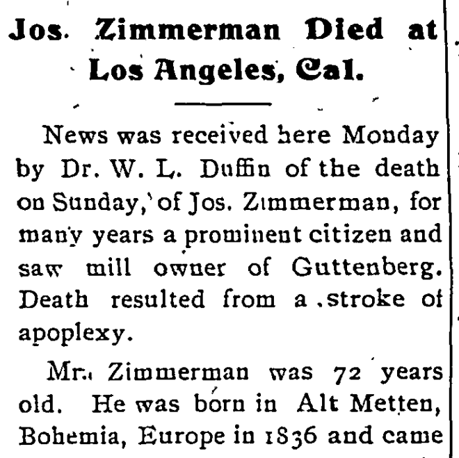
Unlike other evidence which listed either Austria or Baden as his place of birth, this obituary gives a fairly precise location: Alt Metten in Bohemia.

Being the curious and detailed person that I am, I want to know where Alt Metten was. I know there are gazetteers for historical Germany, but I didn’t know offhand if any such things cover the Austrian Empire or Bohemia in particular. And I like maps. So I perused the David Rumsey map collection web site to see if it had any for Bohemia. It does, and the approximate date is 1838, which is really close to Joseph Zimmerman’s year of birth.

Unfortunately, Alt Metten was not immediately apparent. So I made a copy of the map and, using GIMP, started crossing off place names that were not Alt Metten. Below you will see my handiwork, which is still not complete. The red marks tick off places that are within the Kingdom of Bohemia according to the map. Then I started with yellow marks for places outside the borders shown but which could conceivably be considered Bohemia. A couple of places I circled in green for further checking in case I can’t find better candidates. I still have some places to check.

Map of Kingdom of Bohemia  from Allgemeiner Hand Atlas der Ganzen Erde
Map of Kingdom of Bohemia from Allgemeiner Hand Atlas der Ganzen Erde

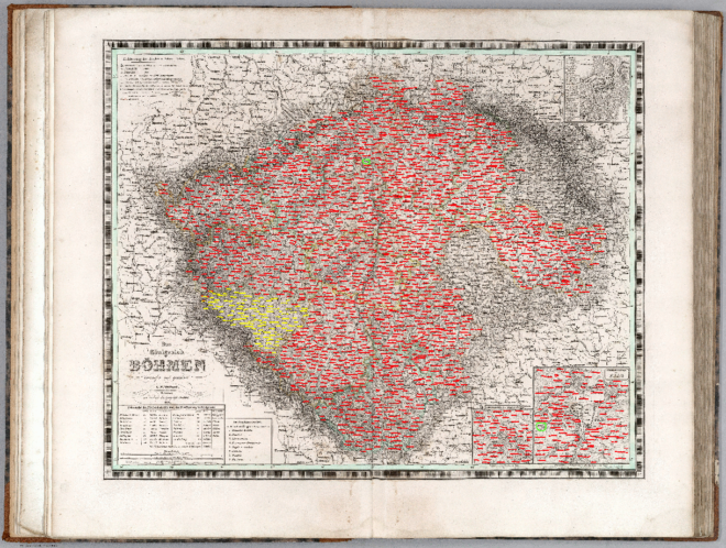
So far, nothing that is clearly Alt Metten.

Post-glacial Rebound near Håkansön

I attended a genealogy seminar on 25 September 2016 at the Swedish Club in Seattle, put on by SwedGen. The final portion was on the historical maps available from Landmäteriet. I’ve used that web site for the current maps, mostly as a gazetteer. I didn’t know the historical maps were available.

So I poked around looking for maps of Håkansön, the village where both my great grandparents are from. Some of the old church records identify the farm numbers where my family lived. Unfortunately, I haven’t found any land reform maps for the village, which would show the individual farms.

But there were some general maps for the area, and I noticed something interesting. The first image is from Google Maps of the peninsula today. The marker on it shows where Håkansön was according to the old maps (I thought it was slightly south of there).

Map of Klubbviken 2016
Klubbviken 2016

The second image is of the same area on a map identified as being from 1858-78. The peninsula is shorter, with an island just off the tip.

Map of Klubbviken from 1859-78
Klubbviken 1859-78

What was an island in the 1800s is now part of the mainland. I’m betting the change in sea level is due to post-glacial rebound. The entire area was under thousands of feet of ice 20,000 years ago. and it is now rising because the weight no longer presses down.

Kind of neat to see a long term geological process actually reflected in the maps.

Patrick Parker in Grant County

My genealogy white whale since shortly after I started has been finding Patrick Parker and his wife Mary Murphy. I’ve written about them here multiple times. I’d found pretty solid evidence on what happened to 8 of their 10 children, the only two where I was missing basic information were the sons James and John. Last month I found good evidence for James. Two weeks ago I found John, though I haven’t pursued it much yet.

But as much information as I’ve found on all their children, the evidence I have for the pair themselves is aggravatingly small. I’ve located them together in the 1851 Canada Census, the 1860 US Census, and the 1870 US Census. I have a possible grave site for Patrick in Iowa. And Mary Murphy can be found in the 1885 Iowa Census. That’s the sum total of direct evidence I have for them.

I have indirect evidence for them. I know they arrived in Canada between 1832 and 1835, based on the listed countries of birth for their children. The death records for several children list their names. The grave marker for my great great grandmother Mary Parker Ryan gives a place of birth for her, which places Mary Murphy in that place at least.

Today I was looking through the online maps collection for the Wisconsin Historical Society, and I saw they had added a map for Grant County from 1868, and the description included “shows townships and sections, landownership, …” The earliest landownership map for Grant County that I’ve viewed came from 1878 and the Parkers were not to be found on it. So, I took a peek at the 1868 map:

1868 map of Grant County, Wisconsin showing the Parker and Ryan farms highlighed

Lo and behold, there he is! The P. Parker farm is just southwest of North Andover (a town which is no longer a town). On the map, I also highlighted the location of the farm for Patrick Parker’s son in law, William Dennis Ryan. And with handy Google Maps, I can show you where the Parker farm is on today’s maps.

This is the first direct piece of evidence for their existence that I’ve found in nearly 2 years. You don’t know how thrilled I am about this.